Sunshine Village to Assiniboine to Mt. Shark TH 60km Fastpack Day Run - BC/AB
Elevation Gain:  ~800m
July 22, 2017 :::: Group Start Time 0600, Saturday
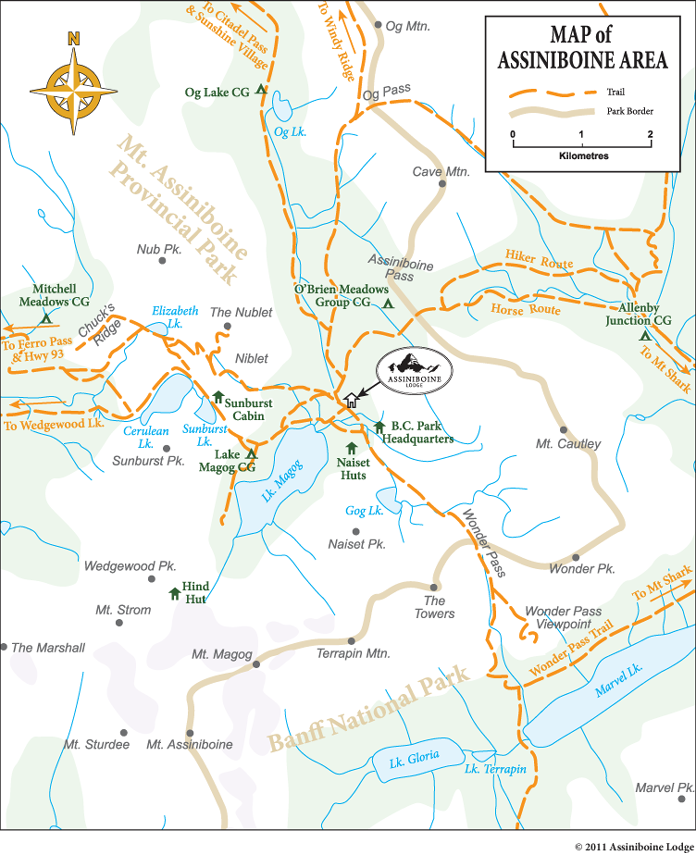
At least one vehicle will be staged at Mt. Shark TH. Mt. Assiniboine can also be reached from the Sunshine Village ski area via the rambling alpine meadows of Citadel Pass. We'll plan to run up the Sunshine Village limited access ski area maintenance road for 6.5 km to the base village. The run will conclude at the Mt. Shark trailhead in Kananaskis Country, Alberta. There are seasonal trail restrictions on Allenby Pass and Assiniboine Pass during buffalo berry season, so we will be going over Wonder Pass alternatively.
Sunshine Village Ski Resort to Assiniboine Lodge
Distance: 27.5 km (17.1 miles) plus 6.5 km (4 miles)
Elevation gain: 400 meter gain (1,312 feet)
Maximum elevation: 2,360 meters (7,750 feet)
TH: Sunshine Village Ski and Snowboard Resort up Healy Creek west of Banff
Starting Parking lot: Sunshine Village Ski and Snowboard Resort parking lot
No Day Permit Required; I have topo maps; bring bear spray if you can't run faster than me!!!!

Trail description
Follow Sunshine Interpretive Center follow the Citadel Pass trail uphill to the southeast. After a brief climb, reach the alpine meadows of the Great Divide (1.2 km). At the Rock Isle lake Junction (1.3 km) turn left to Citadel Pass. After crossing a ridge underneath Quartz Hill the trail drops down to a Banff National Park campground on the shores of Howard Douglas Lake (5.8 km). Fill your bottles at Howard Douglas Lake as it might be the last water before Og Lake.
On the summit of Citadel Pass (9.3 km-2,360 meters) continue straight ahead on the Og Lake/Assiniboine Trail. There is a steep descent down Citadel Pass and a junction to the first Assiniboine Provincial Park campground on the Sunshine access route at Porcupine (12.5 km). If you are a though hiker and not camping at Porcupine, do not dip down into the Golden Valley. Follow the traverse on the steep open side hill. Enter Valley of the Rocks, a bizarre jumble of rocks from an ancient landslide. There is no water in this 6 km section. Travel past the Og Lake Campground (22.2 km), with the spectacular view of Mount Assiniboine.
Cross
the expansive Og Meadows. Continue straight ahead at the
Og Pass junction (26.3 km) and up a gully. Continue in
the direction of travel at the trail junction for Assiniboine
Pass (27.0 km). At the next Y junction (27.3), follow
the trail branching to the right for the Magog Campground.
The Magog Campground is 1.4 km km from this junction.
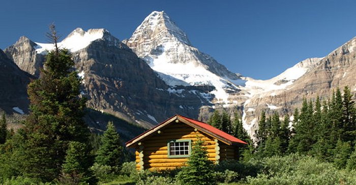
Take the trail branching to the left for Assiniboine Lodge
and the Naiset Huts. Assiniboine Lodge is 200 meters from
the junction. For the Naiset Huts continue past Assiniboine
Lodge and turn left after the second lodge cabin. The
Naiset Huts are 500 meters past the Assiniboine Lodge
towards Wonder Pass.
Assiniboine Lodge to the Mount Shark TH via Wonder Pass and Bryant Creek Distance: 26.1 km (17 miles)The scenery on this route is spectacular. From Assiniboine Lodge, hike past the Naiset Huts (0.5 km) and along Gog Creek. Shortly after crossing the creek (1.1 km) you will reach Gog Lake. In 1983, great blue herons nested Gog Lake- the highest nesting elevation recorded for this species. From here the trail climbs through larch forests and open meadows filled with wildflowers to Wonder Pass (3.1 km). At Wonder Pass, the trail continues into Banff National Park in subalpine terrain. After the first view of Marvel Lake the trail steadily descends in a series of switchbacks. Keep left (southeast) at the Marvel Pass junction (6 km). The Wonder Pass Trail traverses across a number of large avalanche slopes on the southern flanks of Wonder Peak.
Elevation gain: 205 meters (670 feet)
Elevation loss: 580 meters (1,900 feet)
Maximum elevation: 2395 meters (7,850 feet)
Finishing Parking lot: The Mount Shark Trail Head Trail closures: The hikers high trail over Assiniboine Pass is closed between August 1st-September 30th to reduce human-grizzly bear conflicts. Assiniboine Pass can be reached via the lower horse trail, so we will be using Wonder Pass alternatively. Trail Description
The trail re-enters the forest at the east end of Marvel Lake. Continue straight on the main trail at Marvel Lake Campground junction (10.6 km). Cross Bryant Creek bridge (11.6 km). Connect and turn right at the Bryant Creek/Assiniboine Pass Trail (11.9 km). Continue past the Bryant Creek Warden's Cabin (14.3 km). Pass the first of the overnight options located in Banff National Park- McBride’s Campground BR14 (14km). Next you will pass the primitive Bryant Creek Shelter (13.6 km) located in the clearing. The next junction is for the Marvel Lake BR13 Campground (13 km), which is followed by the Owl Lake Junction (12 km). The last campground is Big Springs Campground BR 9 (9.6 km). At Trail Centre (6.7 km) and a junction for a Banff National Park Warden's Cabin, continue straight. The trail forks with the left fork leading to Spray Lake northwest shore. Take the right fork (south) following signs for Mount Shark Trailhead. Cross the Bryant Creek Bridge (6.6 km) and turn left (east) at the Palliser Junction (6 km). Cross the Upper Spray River Bridge (5.9 km). The trail goes up a steep hill and becomes a road as you approach Watridge Lake/Karst turnoff (3.7 km). Travel along an old logging road and notice the maze of ski trails intersecting the Assiniboine trail. Follow the road to the Mount Shark Trailhead.

Marvel Lake from Wonder Pass