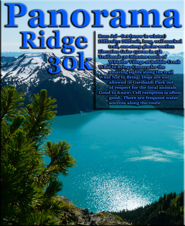
Panorama Ridge and Black Tusk 37K Run, Whistler, British Columbia
Elevation Gain: 5655'     Elevation: 7608'
July 30-31, 2017
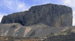
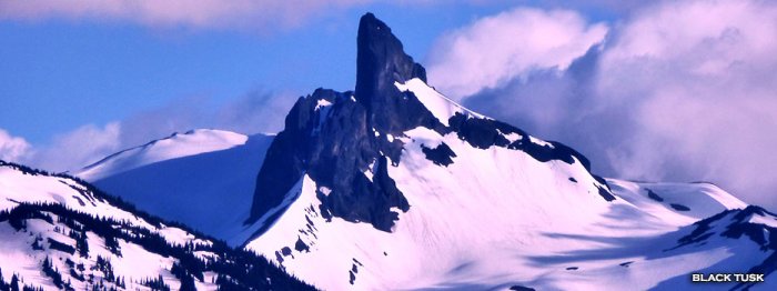
Black Tusk is the extraordinarily iconic and appropriately named mountain that can be seen from almost everywhere in Whistler. The massive black spire of crumbling rock juts out of the earth in an incredibly distinct way that appears like an enormous black tusk plunging out of the ground. About 170,000 years ago renewed volcanic activity in what is now Garibaldi Park produced a lava dome within a cinder-rich volcanic cone itself over a million years old. Cinder-rich simply means that the cone formed out of explosive volcanic action and hardened, to some extent, in the air and therefore filled with air pockets and evidently light and weak in structure. This lava dome which was to become Black Black Tusk from Whistler MountainTusk, hardened inside this more easily eroded cinder cone, so in the past 170,000 years the outer cinder cone has crumbled away to reveal the lava dome within. The Black Tusk itself is extremely crumbly as well as can be seen when you near it. It looks as if erupting out of a uniformly sloping mountain of jagged, black boulders. Black Tusk is within the Garibaldi Volcanic Belt also called the Canadian Cascade Arc. This volcanic belt contains mostly dormant volcanoes, though also includes the much alive and infamous Mount St. Helens in Washington State, in the US. Mount Garibaldi from which Garibaldi Park gets its name was an active volcano as recently as 9300 years ago. Also in the area but well north of Black Tusk near Pemberton, Mount Meager had multiple eruptions ending only recently, that is 2350 years ago according to recent studies. Meager now has become known in the region for its alarmingly frequent mudslides that terrorize the Meager Creek Hot Springs below and the town of Pemberton further down the valley. The last mudslide occurred just a couple years ago and was one of the largest in recorded Canadian history. Pemberton was partly evacuated as a result.
The two closest campsites to Black Tusk
are the Taylor Meadows campsite and the
Garibaldi Lake campsite. Both can be accessed
from the Rubble Creek parking lot and
involve approximately a 9km hike to either
campsite. On weekends in the summer, the
Garibaldi Lake campsite tends to fill
up quickly and Taylor Meadows becomes
the overflow camping spot in the area.
Both campsites have pit toilets, however
there is no running or drinkable water
and all garbage must be packed out with
you. Camping fees must be paid before
you leave the Rubble Creek parking lot
and you must have proof of payment on
you at all times. There are no reservations
and campsites are on a first come, first
serve basis. Generally the park rangers
will post a sign at the trailhead or just
after the 6km marker if the Garibaldi
campsite is full. Hiking to Black Tusk
in one day is a long trip, so for most
people, it is a better option to camp
over night. Panorama Ridge can also be
explored if you camp for 2 nights. For
more camping information in Garibaldi
Provincial Park, visit the BC Parks website
at:
www.env.gov.bc.ca/bcparks/explore/parkpgs/garibaldi/
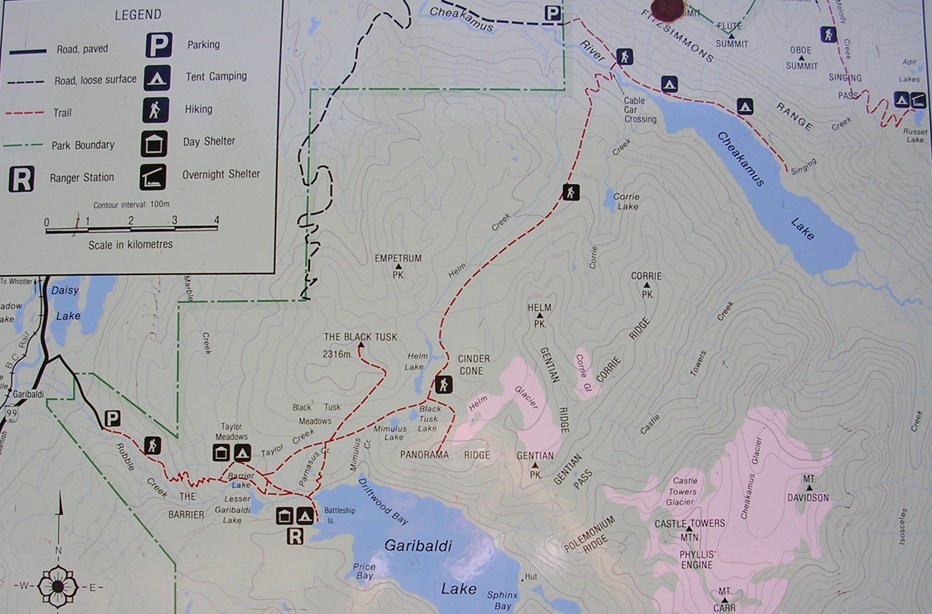
The dark, jagged edges of Black Tusk make it one of the most scenic and unique hikes in southwestern British Columbia. Located in Garibaldi Provincial Park, Black Tusk is the most spectacular mountain in the area. While many hikers do complete this trail in a day, the distance and elevation gain make for a very long day. For this reason, some people prefer to hike to Garibaldi Lake or Taylor Meadows and camp overnight, and then hike to Black Tusk the following day. It is up to you which you prefer, however if you do decide to do this in a day, make sure to leave plenty of time to return to the parking lot during daylight hours. Start your hike from the wooden steps in the upper section of the Rubble Creek parking lot. The dirt trail climbs steadily for the first 6km until you reach a junction. Going right takes you to Garibaldi Lake, so take the trail to the left to head up towards Taylor Meadows and eventually on to Black Tusk. The trail continues to climb gradually eventually emerging from the forest and into more wide open space as you enter into Taylor Meadows. Continue along the trail as it enters into the Taylor Meadows campsite area. Pass the camping area and continue along the trail as it meanders through the meadows. In the late summer and early fall, the alpine flowers are in full bloom and their beautiful colours are scattered across the land like a beautiful piece of art. Eventually, you arrive at a junction with a map and wooden bench. Continue going straight along the trail for a short distance and watch for a sign and trail on your left that point the way to Black Tusk. Take this trail and immediately start your uphill trek. The trail climbs quickly, passing over small runoff streams and evidence of rockslides that have occurred over thousands of years. As you gain elevation, look back occasionally at the view of Garibaldi Lake below. As the trail continues, the trees and vegetation become fewer eventually giving way to a completely rocky terrain. The trail emerges onto a small ridge at a BC Parks sign with a full view of Black Tusk ahead of you. From this point on, BC Parks does not maintain a trail, however evidence of a path is still visible from the many hikers who trek through here each year. The next section of trail is a scramble over loose shale towards the base of the Tusk. Read the BC Parks sign carefully and understand that continuing further is at your own risk. Passing the BC Parks sign will begin with a steep uphill climb. The loose shale slides with each step you take making it seem like you slide back one step for every two steps you move forward. The trail eventually emerges onto a ridge next to the base of the Tusk that offers a scenic view of the entire area surrounding Garibaldi Lake. Be careful on the loose rocks as some of the cliffs in the area are high enough to cause very serious injuries or even death. Most hikers end their hike to the Tusk at this point before heading back. Although it is possible to make it onto the peak of the Tusk it is not recommended as it is extremely dangerous and discouraged by BC Parks. However, it is sometimes attempted by experienced rock climbers with the proper equipment and training. To reach the chute that you can climb to the top, follow the base of the Tusk, stepping carefully to make sure you don't slide down the hill. The shale is very loose and pulling yourself up through the chute generally pulls off pieces of rock from the Tusk. Even experienced rock climbers must keep in mind that they have to come back down this same route. After enjoying the view, it's time to head back down the way you came. Without a clear trail or markings, watch for worn areas of the trail where other hikers have been and aim for the large BC Parks sign that you passed on your way up. Once at the BC Parks sign the trail markings appear as does the vegetation. Continue back down the path towards Taylor Meadows and go right when you reach the junction of the main trail.
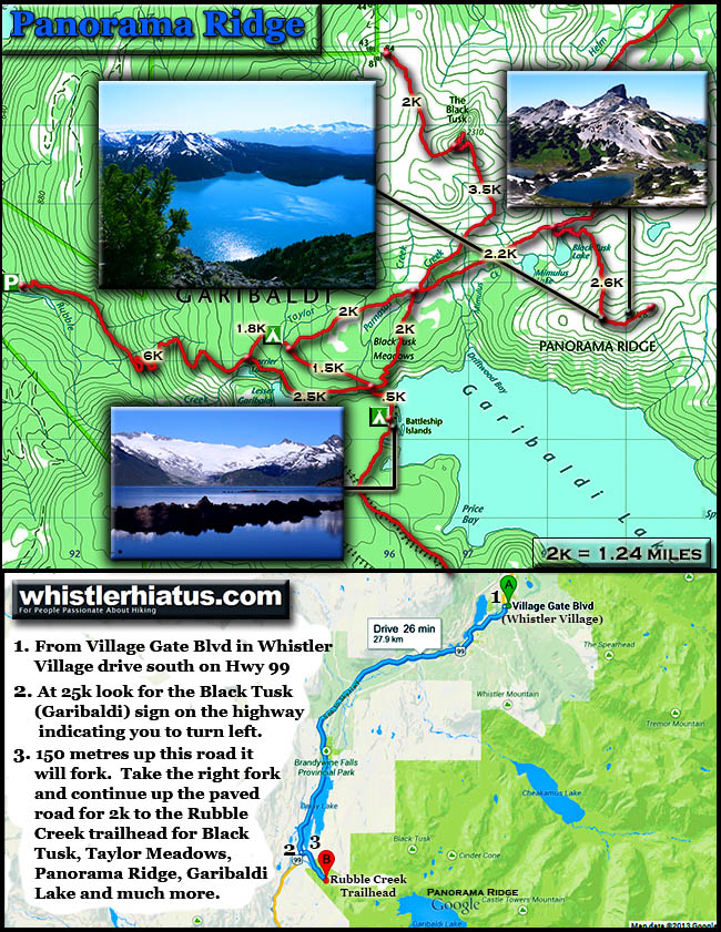
Back at the Taylor Meadows junction, it is possible to do a side trip to Garibaldi Lake and return a different route to the parking lot if time permits. If you're short on time, go straight through Taylor Meadows, back the way you came to the first junction. However, if you have a bit of extra time and energy, go left towards Garibaldi Lake. After a bit more walking through the meadows and a downhill section through a series of switchbacks that head down to the lake, a trail appears on the left. Follow the trail as it merges with the river and cross the bridge to the other side. Walk along the lake side to the clearing to see a full view of the lake and glacier. On a hot day, the cold water of Garibaldi Lake can feel nice to dip your feet into. After you have rested and taken in the lake view, head back towards the bridge crossing the river and back up the steep dirt trail. Turn left at the sign and continue for the next 3km, passing two smaller lakes before reaching the first junction. From this junction, continue straight for the next 6km back towards the Rubble Creek parking lot. The sound of Rubble Creek far below starts to get louder as you near your destination.
How to get to Black Tusk - Estimated Driving Time from Vancouver: 1 hour 45 minutes - To reach the Rubble Creek parking lot, the start of the trail to Black Tusk via the Garibaldi Lake area, take Highway #1 (Trans Canada Highway) west towards Horseshoe Bay. Just before the ferry terminal, watch for signs to Squamish and merge onto Highway #99 North (Sea to Sky Highway). Continue driving along the highway until reaching the town of Squamish 45km later. At this point, it's a good idea to make sure you have enough gas, water, and food for the day as there are no other places to stop between here and the trailhead. Continue along Highway #99 northbound towards Whistler for another 32km. Watch for Garibaldi Provincial Park signs on your right. The turnoff is a small, paved road on the right of the highway that is easy to miss. If you pass over a bridge with a large dam on the right, you have just passed it and will have to find a place to turn around and head back. Once on the Rubble Creek Road, continue for a couple of kilometers until you reach the parking lot. Make sure to buy a ticket from the parking meter before beginning your hike. View a map of Driving directions to Black Tusk.

The Cheakamus Lake trailhead route to get to Black Tusk is a good option as it is quiet, serene and takes you over the beautiful Cheakamus River via suspension bridge and through the wonderfully remote Helm Creek campground. It is, however, quite long at over 15 kilometres each way to the summit of Black Tusk and part of this route is unmarked, requires some route-finding, and a wet crossing of Helm Creek. It is a good option if you are keen on avoiding crowds as the beautiful Helm Creek campground has only about a dozen tent platforms and more often than not, are mostly deserted. Helm Creek is also the gateway to quite a few great great hikes. A quick look at a map indicates several accessible mountains close by as well as Corrie Lake. The most popular, scenic and direct hiking trail to Black Tusk is from the popular Rubble Creek trailhead, just off the Sea to Sky Highway, 25 kilometres south of Whistler Village. As this trailhead is also the best route to access Garibaldi Lake, Taylor Meadows and Panorama Ridge, it is sometimes very busy and some weekends find both campgrounds full. Black Tusk from Helm CreekThe Rubble Creek trailhead is easy to find, just keep your eye out for the large highway sign that reads, "Black Tusk(Garibaldi)" along the side of the Sea to Sky Highway 25 kilometres south of Whistler Village. The huge and free trailhead parking has a map and information board as well as an outhouse. Rubble Creek is so named because of the large boulder field deposited from The Barrier is previous, massive debris flows. The last occurred 80 years ago, when The Barrier partly gave way and an estimated thirty million cubic metres of rock crashed down near the now, Rubble Creek trailhead. The Barrier can be viewed along the trail to Garibaldi Lake just past the y junction after the 6k mark along the trail. A sign indicates the short path to the viewpoint. The trail from Rubble Creek starts off by quickly ascending along a wide dirt path inside a deep forest. For the first 6 kilometres you only catch glimpses of the sky through the the deep and thick forest. Several switchbacks along the trail continue until you get to the first fork in the trail about 6.2 kilometres from the trailhead. Right takes you to past the Barrier, Lesser Garibaldi Lake and then to Garibaldi Lake (in 3 kilometres).
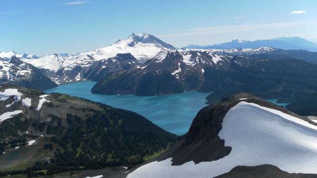
There is a nice mapboard at this trail junction which gives you a good chance to plot your course. A good way to hike if doing a one day hike is to take this left fork through Black Tusk Trail View of Garibaldi LakeTaylor Meadows and then return via Garibaldi Lake for a swim near the end of the journey. The Taylor Meadows route is also slightly shorter to Black Tusk than the Garibaldi Lake direction and therefore gets you to your goal quicker. If you take the left fork toward Taylor Meadows you will finally escape the heavy forest cover and emerge to spectacular scenery in about 20 minutes. Taylor Meadows is in a beautiful valley of gnarled, weather beaten trees, endless green meadows and in July and August, alpine flowers as far as you can see. What immediately comes into view towering in the distance is Black Tusk and the wooden boardwalk through Taylor Meadows continues straight as Black Tusk looms far ahead and to your left. This is where you will start taking photos almost continuously of Black Tusk, and probably not stop until you touch its sheer black sides. Though you are only half way there, from now on the views from the trail are amazing, varied, and progressively better. Just past Taylor Meadows the boardwalk ends and the dirt trail crosses a creek and then past a small, locked BC Parks building and another trail junction. The trail to the right leads to Garibaldi Lake and campsite area in 2 kilometres. The trail that continues straight goes to Black Tusk(5.5k), the Panorama Ridge(7k) and much further away, Helm Creek(9.2k) and Cheakamus Lake(18k). The views along this 2 kilometre section of trail between this junction and the Black Tusk junction are beautiful. Green meadows, flowers everywhere you look. Distant snow capped Garibaldi Lake from the Black Tusk Trailmountains and the starkly beautiful Black Tusk towering to your left. The next junction you come to has a nice mapboard and more nice kilometre markings and direction signs. Once again you can turn right and head towards Garibaldi Lake or continue straight for Black Tusk, Panorama Ridge, Helm Creek and Cheakamus Lake. There is an outhouse here and ropes along the edge of the trail here to try to keep hikers on the trail. The area is ideal for camping with a beautiful creek and endless flat grassy areas, however a sign indicates not to camp here in order to not damage the fragile alpine areas off the trail. In just a hundred metres further another fork in the trail takes you left towards Black Tusk(3k) or straight toward Panorama Ridge(4.5k), and you begin ascending steadily through patches of forest occasionally breaking to reveal amazing views of Garibaldi Lake to your right and Black Tusk on your left. This section of trail, from this junction to Black Tusk is fairly steep and the most challenging. You will cross dozens of tiny creeks so water is never in short supply. This section of trail is often snow covered well into July, however, the snow is hard-packed, easy to walk on, and the trail is hard to stray from. Black Tusk Summit View of Garibaldi LakeAs you approach Black Tusk you will begin walking on the massive scree slopes that surround it. On a sunny day you will immediately feel the warmth from the black rocks underfoot. Due to the increasing elevation the temperatures will have noticeably fallen quite a bit as compared to Taylor Meadows, however the heat from the black rocks on a sunny day more than counter this drop in temperature. You will likely find yourself putting on a sweater after the Black Tusk junction and then taking it off again once you near Black Tusk and feel this heat rising from the ground. The steep scree slope leads to a ridge adjacent to Black Tusk. To your left the obvious route takes you to Black Tusk and the increasingly sketchy route along the edge of its base. Following this route you will occasionally look straight up and while marvelling at the enormous, vertical edge of Black Tusk, wonder about odds of one of the millions of crumbling chunks of Black Tusk dropping from high above, onto your head. As you scramble along the edge of Black Tusk you come to a chute heading almost straight up. Then another chute, this second one is marked with an orange trail marker. Again, even this close you will wonder, as almost everyone else at this spot, “I don’t think this is a safe way to go.” Then you pause and look around, taking in the view, spectacular. Just spectacular.Black Tusk Summit View. Above the clouds, looking over the impossibly blue Garibaldi Lake, nestled in endless snowy mountains. There is even snow, more accurately a glacier just below you, in the valleys of scree that crumbled from Black Tusk. The scree is black, very black. Basketball sized boulders litter the glacier far below. Contrasting colours of the snow, clouds, lake and sky, the view is breathtaking. Most people don’t continue up the final chute to the top, it’s that scary looking. This is justifiable. It is unquestionably unsafe. Chunky rock holds pull free as you grip them. Above you jet black, jagged rocks tumble and ricochet down on and around you. And the view is so spectacular around you that it’s easy to justify turning around here. But the final ascent is not really that hard. Keep your head down, three points of contact at all times, slow and steady and you reach the top of the world.