 Monroe Skyline on the Long Trail in Vermont
Elevation Range:  2371' - 4083'       MAP
May
22-24, 2016
- To TH: From Montpelier, VT, take US
2 W to Vermont 100B S
(becomes Main St.). In 13.3 miles, turn
right at VT 17 W. In 0.1 mile, turn right
at
Mill Brook Rd./VT 17 W. Go 6 miles to
leave a car at Appalachian Gap. No permit
requirements. Expect 8,000 feet of ups
and downs, challenging routefinding around
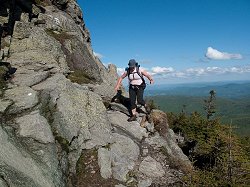
blow-downs , hand-over-hand scrambles
up steep granite slabs, and thin sidehill
traverses. No pain, no gain, right? You’ll
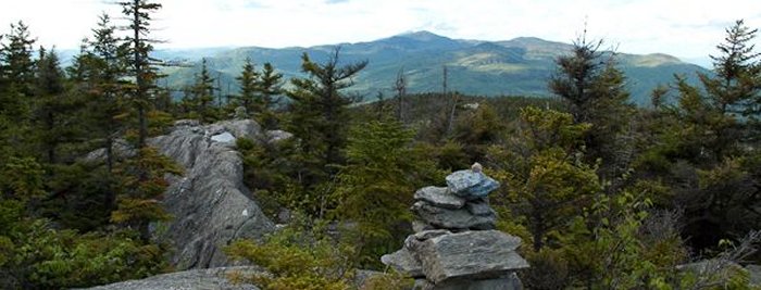
enjoy wicked multistate views from the
tips of the ’Dacks all the way down
to the surface of Lake Champlain. The
bald, 4,083-foot summit of Camel’s
Hump, which is this section’s crux,
features rare (for this latitude) alpine
vegetation and a stone lodge for weary
hikers. You’ll also find pure solitude
on seldom-traveled Mts. Ira Allen and
Ethan Allen, and then finish up by descending
one of the Long Trail’s few long,
rocky ridgewalks.
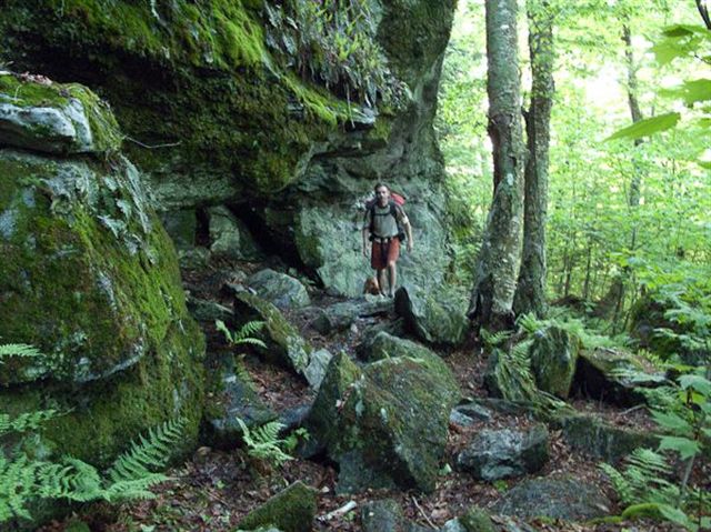
Starting from Lincoln Gap follow white blazes north on the Long Trail toward Jonesville. Named for Professor Will Monroe who led the effort to build this section, it’s a stunning hike with three out of five of Vermont’s highest peaks. It’s also a great section to hike because it crosses two of Vermont’s best ski areas, at Sugarbush ski area’s Summit Quad lift hut. Heading towards Mad River Glen, the terrain starts to get a little more rugged with many new blow-downs in the trail and some ladders to descend. Take a break at Stark’s Nest near the top of Mad River Glen’s iconic single chairlift. Mad River Glen keeps the Stark’s Nest open all summer long, and it’s a great place to hang out on the deck and take in beautiful views to the east. Water is plentiful on the trail with easy navigation along the well-marked route. The Long Trail, which is the nation’s first and oldest long-distance hiking trail, is notoriously gnarly. Early trail builders such as Monroe (in 1916!), didn’t bother to ease the pain of steep ascents with switchbacks. Instead, the Trail tends to follow ridgelines and shoots straight up and down over peaks. Hiking any section of the Long Trail is a workout. I am always humbled by the Long Trail because it requires a slower pace and careful foot placement with each step. Knotted roots, wet rocks, blow-downs, and slippery streambeds can reduce a strong hiker to covering one mile an hour or less. And that’s not even going uphill!
The start is a 1600' climb over 2.5 miles to the rocky, treeless summit of 4006' Mt. Abraham, Vermont’s fifth highest peak from which you can see the Adirondacks fifty miles west and the Whites to the East. The trail then crosses the wooded summits of five of Vermont's highest peaks - Lincoln, Nancy Hanks, Cutts, Mt. Ellen, Vermont’s third highest peak at 4,083 ft, and General Stark through stands of spruce and fir. At 9.8 miles asteep descent brings you to Theron Dean Shelter, a small lean-to with a large view where you can make the turnaround for the return journey.. Here you can follow the blue blazes through Dean Cave, a short and narrow underground passage that leads back to the Long Trail. This 11.6-mile traverse is perhaps Vermont's finest section of the 272-mile Long Trail.
The Monroe Skyline Trail travels between two popular Long Trail parking areas, one along Lincoln Road (normally closed in winter) and SR 17 at Appalachian Gap.
This entire route is 30 miles long with the segment between Lincoln Road and SR 17 being a little less than 12 miles. Many people plan to hike this trip as a one night backpack excursion. The hiker encounters 6 summits along the crested ridge.
Many folks begin at the southern location and hike north. Glacial ice and fast moving streams cut the beginning of this trail known as Lincoln Gap. Rock cliffs tower at 2,424 feet. The first ascent is to the Battell Shelter near Mt. Abraham 4,006 feet, which offers the first of many spectacular panoramic views and wonderful specimens of alpine vegetation. The next peak is Lincoln Peak 3,975 feet and onto Nancy Hanks Peak 3,812 feet. There is about a 1.5 mile stretch to Cutts Peak elevation 4,020. Mt. Ellen is just north about .5 mile standing at 4,083 feet. The last peak, which is actually the second mountain along this crest, is General Stark which towers at 3,662 feet. Before reaching this summit, Glen Ellen Shelter is located off a spur trail to the east. Resting on the side of the ridge, the early morning riser is treated to a fabulous sunrise. After negotiating General Stark the trail moves toward Theron Dean Shelter which is located off another short spur. This is an interesting area featuring a small cave. Under less than 2 miles, the trail drops significantly to reach its terminus at Appalachian Gap.
Note: Both ends of this trail offer overnight shelters. Battell Shelter to the south and Theron Dean Shelter at the north end. Also, Glen Ellen Lodge just north of the junction with Jerusalem Trail.
Directions from Lincoln, VT: Travel east on Lincoln Road for about 4 miles to Lincoln Gap.