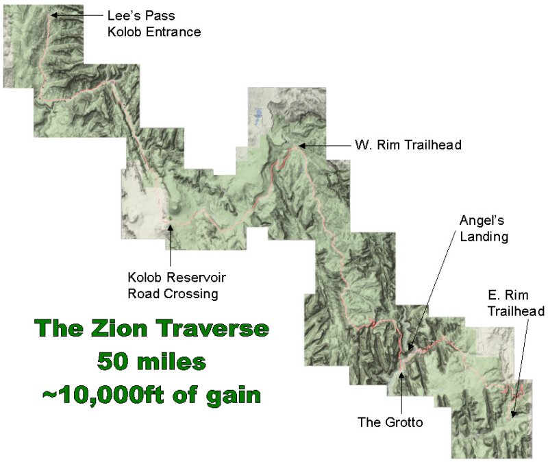
Friday, May 1, 2020 Zion National Park Traverse Utah
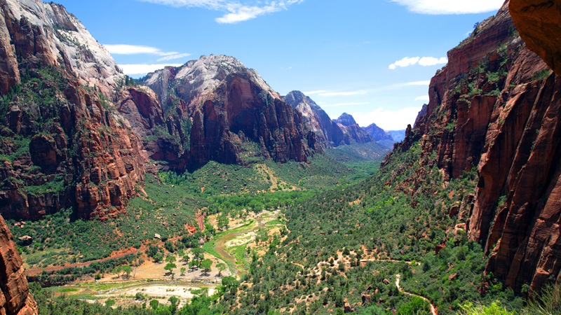
From Lee Pass, the route descends south through Timber Creek to La Verkin Creek, which it gradually climbs east towards the Hop Valley Trail. To get around a drop-off the trail switchbacks to a bench above Hop Valley before dropping down to the broad valley floor, where the trail becomes faint. The route passes through private land up this cattle-grazed valley until it goes through another gate near its head. Before the route reaches the Hop Valley Trailhead, it makes a sharp turn left/east onto the Connector Trail, which is lightly traveled and therefore faint—just pay attention to where you are and where you need to be going. It joins the Wildcat Canyon Trail (labeled as the “Lava Point Tr” on the USGS map) and climbs gradually to the West Rim Trailhead. The next section along Horse Pasture Mesa is relatively flat, dry, and shadeless, especially after the wildfires in 2006 that burned much of the Zion high country. South of Potato Hollow Spring there is a trail junction with West Rim Trail and the Telephone Canyon Trail, the latter of which has been closed due to fire-related hazards. Don’t worry—the views from the West Rim Tr more than compensate for the additional 1.4 miles that you’ll have to run. The Telephone Canyon Tr and West Rim Tr join again near the West Rim (Cabin) Spring, which is 100 m off-trail, before the route begins a long descent down into Zion Canyon, cut by the North Fork of the Virgin River. If you have the energy and time, a side trip up Angel’s Landing is highly recommended. From the Grotto Trailhead, run along the road to the Echo Canyon Trailhead, where you begin the biggest climb of the route. The
section between the trailhead and Stave Spring is one of the best,
featuring phenomenal views of Zion Canyon, a really neat narrows section,
and expansive sandstone slabs. Top off at Stave Spring because the
rest of the route is probably dry. From the spring, climb gradually
for a short while before enjoying a long 5-mile descent to the East
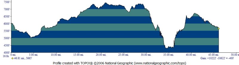
Rim Trailhead. Based on distances in the Park Service’s backcountry brochure combined with distances measured in National Geographic TOPO! mapping software, the route’s distance is 48.3 miles. There are three potential cut-off points en route: Hop Valley Trailhead (Mi 13.6, on Kolob Reservoir Rd), West Rim Trailhead (Mi 22.5, also accessible via Kolob Reservoir Rd), and the North Fork of the Virgin River (Mi 36.7-37.9, on Zion Canyon Scenic Drive), in the event that you or someone in your party does not want to attempt the full distance. For more mileage information, download the Databook. |
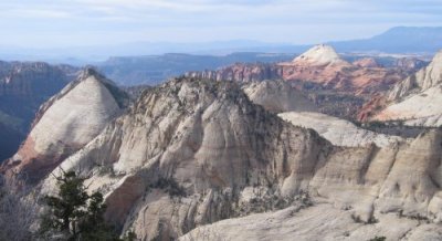 view from West Rim


Vertical Change
There is about 10,000 feet of vertical gain and 10,400 feet of vertical loss over the 48.3-mile route. See the elevation profile for details. (Note that the profile probably slightly overstates the vertical change since the mapmaker had an erratic hand when drawing the route, resulting in some ups and downs in the profile that don’t exist on the ground. Also, the profile is 1.5 miles shorter than the actual distance—it’s tough in a mapping program to account for all of the little twists and turns of the trail.) The western terminus, Lee Pass, is about 400 feet higher than the eastern terminus at the East Rim Trailhead.
Termini
The eastern terminus is the East Rim Trailhead, located on UT-9 within eyesight of the East Ranger Station. The western terminus is Lee Pass, located 4 miles up the hill from Exit 40 on I-15.
Time of Year
There
are two optimal seasons to do the Zion Traverse. The first is in the Spring
(April and May): the high country has just melted out, natural water sources
are flowing, and temperatures are reasonable. The other season is the Fall
(September-November): temperatures have cooled from their summertime highs
and natural water sources are hopefully flowing again after the monsoons.
I would not recommend trying the Traverse in the winter (December-March)—when
considerable snowpack will slow/halt progress and/or pose considerable risk
due to steep snow-covered rock slabs—or in the summer (June-August),
when temperatures will be uncomfortably hot and natural water sources may
be dry.
Eastbound or Westbound
Since
Lee Pass is 400' higher than the East Rim Trailhead, at first glance it
might seem advantageous to go eastbound. However, first-hand experience
and the elevation profile and suggest otherwise: eastbounders must gradually
and consistently climb for 20 miles, from Mi 4.5 in the La Verkin Creek
Valley to Mi ~25.0 at the high point on Horse Pasture Mesa; and they begin
their biggest climb (out of the North Fork) late in the route, at Mi 37.9.
In contrast, while westbounders climb 400' more than eastbounders, they
do their biggest climb early in the route when they are still fresh and
they have a continuous 20-mile stretch of fast run-able downhill. The final
climb to Lee Pass can be a struggle for westbounders but it’s short-and-sweet:
1,000 vertical feet over 4.5 miles.
Time Projection
Elite
ultra-runners should expect the route to take 8-10 hours depending on their
effort. I finished in 9 hrs 27 min after casually running and hiking the
first 20 miles. Karl and Jared finished in 10 hrs 24 minutes, which was
a “fun” pace for them. I think that a strong “record”
time would be under 8 hours. Strong, near-the-front-of-the-pack runners
should expect to finish in 10-13 hours. Recreational and casual runners
can expect to take 13-17 hours.
Car Shuttle & Parking
This run would be difficult—if not impossible—without multiple groups and/or a designated shuttle/support driver. The basic problem is that the termini are inconveniently far apart: 56 road miles and 80 minutes of drive-time.
If you are fortunate enough to have a shuttle driver, they can drop you off at Lee Pass or the East Rim Trailhead in the morning and pick you up at the other terminus in the evening; if they are really nice they can also crew you with fresh water and food along the way (see the “Key Stats” section for possible access points).
If you
have 2+ groups then a “key swap” is the optimal system: it avoids
the need for shuttle drivers and/or having to pick up a car post-run. The
key swap is easy: Group A drives to Lee Pass, hides the key in a key-determined
location, and runs east; Group B drives to East Rim Trailhead, hides the
key, and runs west. When Group A arrives at East Rim Trailhead, they find
the key and drive back to the communal meeting spot (probably a campground
in Zion Canyon or a motel near the South Entrance); when Group B arrives
at Lee Pass, they find the key and also drive back.
Backcountry Camping & Permits
If running
48 miles in a day is not your thing, there are both day-hiking and backpacking
options. You can day-hike from vehicle access point to vehicle access point
(see “Key Stats,” above). Or you can camp en route at any number
of backcountry campsites. Visit the NPS site for more backcountry information
(see the links below).
Water Sources
Water is relatively abundant in Zion compared to most of the Colorado Plateau and there are ample opportunities to tank up or top off, especially in the spring when springs and pools are full of snowmelt.
There are at least two permanent water sources en route: La Verkin Creek and the North Fork; there is also a good spigot near the bathrooms at Grotto Trailhead, which will have better water than the North Fork.
Beatty Spring, Potato Hollow Spring, West Rim (Cabin) Spring, and Stave Spring are all mostly reliable, if not permanent.
Hop Valley is flowing most of the year, but this valley is grazed and the water can be foul, so plan to bypass it or plan to purify it.
It is
likely that you will find more water sources than mentioned here, especially
in the eastern half.