Rockwall Trail 55K Trail Run in Kootenay NP, BC, Canada
Elevation Gain: 6075', Loss: 6325 - North to South
July 19, 2017 (Wednesday) CURRENT TRAIL CONDITIONS
GETTING THERE:
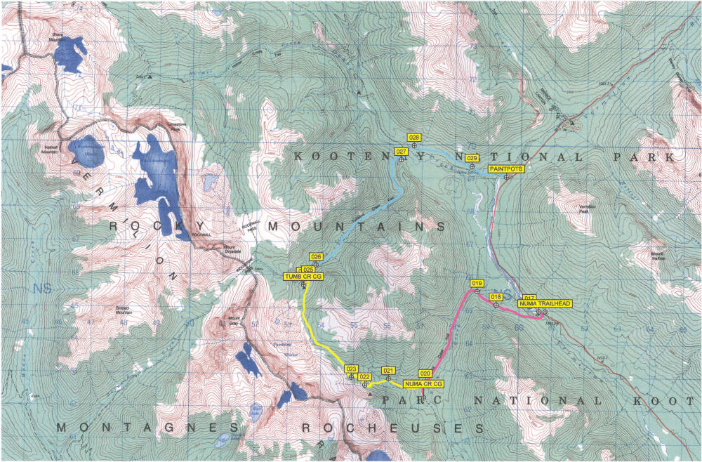
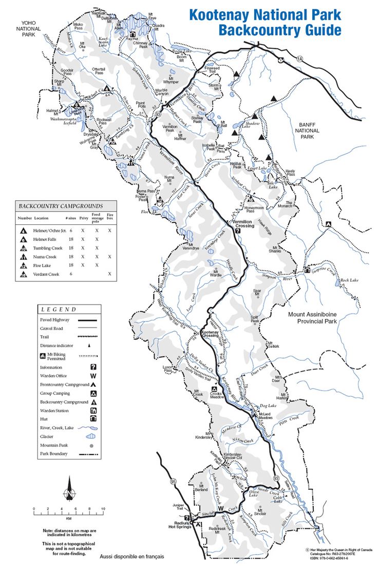
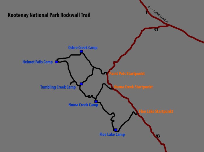
The Rockwall Trail is accessed by one of four creek drainages to the east (Helmet Creek, Tumbling Creek, Numa Creek, or Floe Creek) or by Wolverine Pass from the west. For those doing the entire trail, you will either begin at the Floe Lake Trailhead (for those hiking south to north) or the Paint Pots Trailhead (for those hiking north to south). Both are located on Highway 93 South – the only major road running through Kootenay National Park. If you are approaching from the Trans-Canada Highway, turn south at Castle Junction in Banff National Park onto Highway 93 South. Drive approximately 19 km to the Paint Pots Trailhead parking lot or a further 13 km to the Floe Lake Trailhead parking lot. Both parking lots are clearly signed. From the south, take the turnoff into Kootenay National Park from the town of Radium. Drive to the northern part of the park, watching for the signs for the Floe Lake Trailhead or the Paint Pots Trailhead - depending on your chosen starting point. The Rockwall Trail is not a loop, however, after hiking its 55.6 km, you will only be 13 km from where you began. Two vehicles or hitchhiking will be needed to get you from one trailhead to the other.
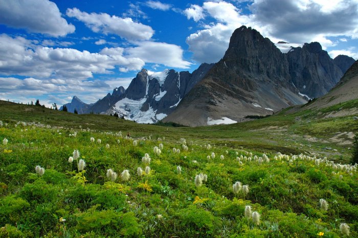
This 55.6 km trail leads one under 30 km of an almost unbroken wall of limestone cliffs towering 900m (2950 feet) above their base in places. In addition to the obviously majestic alpine scenery this massive limestone wall provides, the trail is also punctuated with hanging glaciers, stunning wildflower meadows, larch forests, one of the highest waterfalls in the Canadian Rockies, and three high alpine passes.
he Rockwall is the eastern escarpment of the Vermilion Range in the Canadian Rocky Mountains. The Vermilion Range and Kootenay National Park are representative of the ranges on the western edge of the Rocky Mountains.
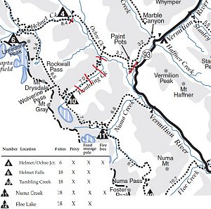
The north end of the hike passes by ochre beds and paint pots which were used by the Ktunaxa, Stoney, and Blackfoot tribes to make dyes and paints used in ceremonies and for trade. Later, the Europeans also harvested the ochre from this area as a pigment base for paints (after the 1920’s, this activity was phased out with the protection of the land in mind). Also at the north end of the hike is Helmet Falls, one of the highest waterfalls in the Canadian Rockies at an estimated height of 352m (1154 feet). Originating from the meltwater of the Washmawapta Icefield, the headwaters of Helmet Creek almost immediately make their dramatic plummet to the valley floor at Helmet Falls. The falls themselves and mountain amphitheater it is situated in are truly breathtaking. At the south end of the hike is Floe Lake, an amazingly beautiful location named after the ice floes breaking off into the lake from the small glacier above it. Hiking between the Floe Lake Trailhead and Floe Lake take you through the burns of the 2003 fires and the regeneration which has been underway since. In between these highlights at the north and south ends of the trek, lies the Rockwall itself and possibly what hiking the trail is known best for – its continuous gain and loss of elevation. The trail is continuously rising and falling as it goes over three different passes - Rockwall Pass, Tumbling Pass, and Numa Pass. Tumbling Glacier and Wolverine Pass (a gap in the Rockwall leading to the west) are yet other remarkable sights found along the journey of the Rockwall Trail. Most everyone is expecting the amazing alpine scenery found along the trail, but perhaps not all will expect the impressive meadows of wildflowers which are common along the way. Particularly interesting is the variety of paintbrush which can be observed. Pink, pink and white, and even yellow paintbrush are to be seen. The trail really is one of the most spectacular backcountry destinations there is. It is a very popular trail in peak season, however, Parks Canada does limit the numbers of people on it at any time by only issuing a certain number of permits for the campgrounds.
The Rockwall Trail is most commonly done from south to north, however, there doesn't seem to be any particular reasonings behind this being the case. In fact, there can be a couple of arguments made for doing it north to south. For one, there is a slight elevation loss when hiking the trail in a southerly direction. The appeal of this factor may seem negligible, especially given all the passes that are gone over. Nevertheless, there is a net elevation loss when going south. Secondly, despite the incredible scenery along the entire length of the trail, some of the most beautiful sights lay waiting at the southern end of the trail. If there is a favourable weather forecast, you may wish to leave Numa Pass and Floe Lake until the end of your trip.
THE ROUTE:
Paint Pots Trailhead to Helmet Falls Campground
Distance:
Approx. 14.7 km
Elevation Gain: 350 m (1150 feet)
If starting from the north, a first time hiker of the Rockwall may worry about doing the longest daily distance on the first day while carrying all their supplies needed for the entire hike. However, this should not be much of a concern. With only 1150 feet of gradual elevation gain, you may look back on this as being one of the easier days on the trip! Much of this day is spent hiking through the trees. You do get occasional views ahead to the mountains and Helmet Creek is certainly a beautiful creek to be hiking along.
From the Paint Pots Trailhead, cross the Vermilion River and follow the interpretive trail to the richly coloured paint pots. Stay left at the junction leading to Marble Canyon and stay right when the junction for the Tumbling Creek Trail is reached. As mentioned previously, all the junctions along the trail are well signed with directions and distances. Approximately 6 km from the highway, you will turn left onto the Helmet Creek Trail which will take you to the Helmet Falls Campground and eventually on to the Rockwall. Shortly after turning onto the Helmet Creek Trail, you will reach the first of the campgrounds along the way – the Helmet/Ochre Junction Campground. This campground does not receive the same traffic as the next four. You have not covered much ground yet and most of the hike done so far has been over relatively flat ground. For most, the Rockwall is beckoning and they must carry on. The Helmet/Ochre Junction Campground is a perfect spot to have lunch, rest the legs, and refill water bottles.
The Helmet Creek Trail ends at the junction of the Goodsir Pass Trail and the Rockwall Trail. Turn left and Helmet Falls Campground is only a short ways further. With a total vertical drop of 352m (1154 feet), Helmet Falls is certainly one of the surprises for many doing the Rockwall Trail. It is an amazing destination in itself. And the mountain amphitheater which surrounds it makes it all the more remarkable. Limestone Peak, Helmet Mountain, and Sharp Mountain frame the scene and it is worth getting up early to see these mountains as the first rays of light hit them in the morning. Above and out of sight, the Washmawapta Icefield and Glacier feed the waterfall.
Helmet Falls Campground to Tumbling Creek Campground
Distance:
Approx. 12.5 km
Elevation Gain to Top of Rockwall Pass: 410 m (1350 feet)
Elevation Loss from Top of Rockwall Pass to Tumbling Creek Campground:
260 m (850 feet)
For those feeling motivated to do so, you can begin this day by taking a side trail that leads you right to the base of Helmet Falls. Take your backpacks and gear along when leaving the campground – the side trail to the waterfall branches off of the main trail. Shortly after this, the climb up Rockwall Pass begins. You hike through some nice stands of larch trees along the way. When you finally break out of the trees, you see the Rockwall for the first time and the incredible scenery which will accompany you all the way to Floe Lake. It really is an awesome sight. From here to Wolverine Pass, you have an uninterrupted wall of limestone rock to the west of you, culminating at Mount Drysdale at the southern end of the wall. Above the Rockwall and out of sight is the Washmawapta Icefield. Between Mount Drysdale and Mount Gray to the south of it is the one break in the limestone bulwark along the length of the Rockwall Trail. This is Wolverine Pass. Through it you can see the Purcell Mountain Range to the west of you. After hiking past Wolverine Pass, the trail makes its way downwards to the next in the line of beautiful campsites at Tumbling Creek.
Tumbling Creek Campground to Numa Creek Campground
Distance:
Approx. 7.7 km
Elevation Gains to Top of Tumbling Pass: 335 m (1100 feet)
Elevation Loss from Top of Tumbling Pass to Numa Creek Campground:
715 m (2350 feet)
The scenery at the start of this day is dominated by Tumbling Glacier and the quite impressive lateral moraine showing how large this glacier used to be. After making your way up and over Tumbling Pass, there is a steep descent down the south side of the pass. You will encounter a few creek crossings here. For the most part, they are not problematic, however, hiking poles can always be useful in these situations.
On the Mount Goodsir 82 N/1 1:50,000 topographic map, the position shown for the Numa Creek campground is incorrect. The map makes the campground appear to be located off the trail and indicates that it is to your right as you descend down the south side of Tumbling Pass. Ignore where the map says it is and continue down the trail. Carry on past the Numa Creek Trail junction and you will find yourself walking through the campground with no detours needed. There is even a sign at the Numa Creek Trail junction telling you which way to go and that you are almost there. For hikers coming from the south, there won’t be any issue as you will find yourself walking through the camp before you would even realize the map was incorrect.
Numa Creek Campground to Floe Lake Campground
Distance:
Approx. 10.0 km
Elevation Gains to Top of Numa Pass: 755 m (2475 feet)
Elevation Loss from Top of Numa Pass to Floe Lake: 250 m (825
feet)
After spending the start of the morning in the trees, this day ends by going up and over Numa Pass, the highest point along the Rockwall Trail at 2355 m (7725 feet). The scenery is spectacular as you head up into the alpine, hiking between Foster Peak to the SW and Numa Mountain to the NE. Being up in the alpine, the trail going over Numa Pass is open and exposed to any elements the weather may throw at you. Snow will often linger on the trail here into late summer and can certainly reappear in early fall. Here, as with anywhere on the trail, precipitation in the form of snow can occur in any month of the year. Markers alongside the trail help people find their way for when there is snow in the higher reaches of Numa Pass. The name Numa comes from the Cree word for thunder. With that in mind, it seems fitting that Numa Mountain was previously named Roaring Mountain.
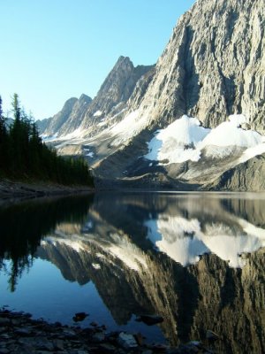
This section of the trail ends with the hike down to Floe Lake. If conditions are clear, the view down to the lake is stunning. Floe Lake, the last in the line of campgrounds along the trail, is a magical spot. Ice floes which calve off of the small glacier there can be seen in the lake and give the lake its name. It is the perfect spot to spend the last night on the trail.
Floe Lake Campground to Floe Lake Trailhead
Distance:
Approx. 10.7 km
Elevation Loss: 700 m (2300 feet)