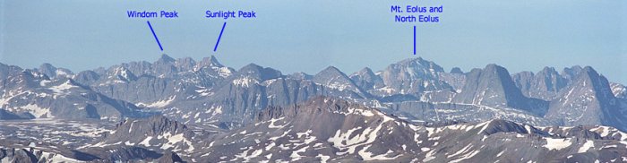
Sunlight, Windom, and Eolus from Purgatory
Weminuche Wilderness, Colorado
Mt.
Eolus lies in what many people believe is the finest range in Colorado,
the San Juans. The northern wall of beautiful Chicago Basin, where
most climbers set up high camp before summiting, is formed by Mt.
Eolus which has two summits, the southern one being the higher one,
and also the highest point in La Plata County (the lower one is
at 14,039 ft). Depending on the weekend, there can be plenty of
people in this 'remote' wilderness. The easiest route is Class 3
with stimulating exposure. The name 'Eolus' is derived from the
Greek god of winds, Aeolus.
Sunlight
Peak, the 39th highest, is one of three 14ers located deep in the
rugged Needle Mountains of Southwestern Colorado. These peaks are
remote and are distinguishable by their mass of spiny ridges, broken
slopes, and craggy summits. Sunlight hides in the northeast corner
of Chicago Basin and is visible only to those who dare approach her.
Sunlight is famous for it's exposed summit block. Some consider the
move onto this block as the single hardest move on a 14er by it's
easiest route. From the summit of Sunlight, there is a great view
of Arrow and Vestal peaks of the Grenadiers to the north. These peaks
are two of the most challenging and picturesque in Colorado. Sunlight,
together with Eolus and Windom guard Chicago Basin well and make any
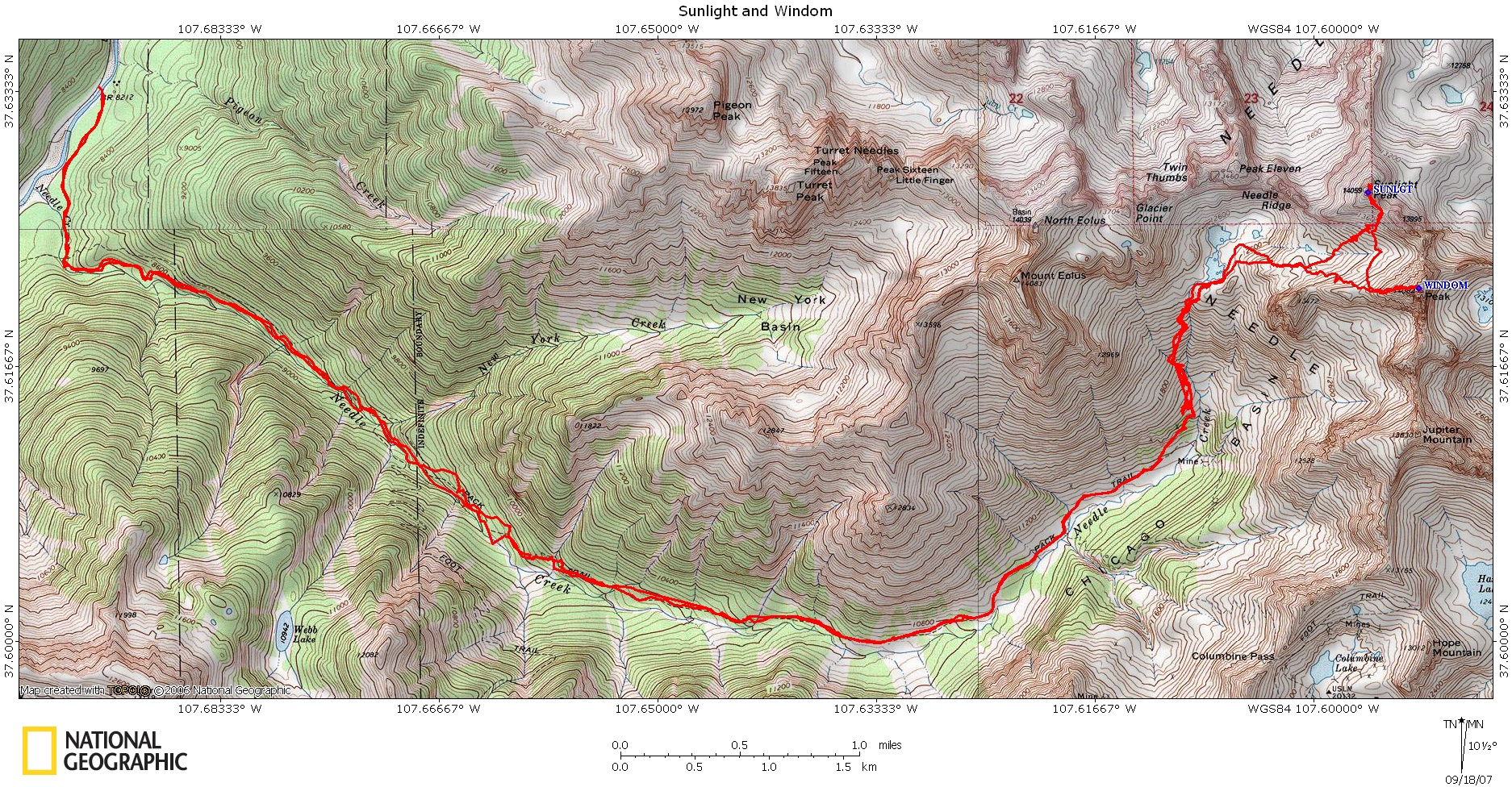
trip worthwhile. Windom Peak is the 34th highest peak in Colorado and is part of a group of three fourteeners- Sunlight, Windom, and Eolus. It is usually climbed the same day as Sunlight. The group is quite remote by Colorado standards and quite removed from civilization. The easiest route is mostly class 1 and a bit of class 2. DIRECTIONS: The nearest trailhead reachable by car starts from the forest service campground across from the Purgatory ski area on US550, 20 miles south of Silverton and 27 miles north of Durango. The round trip distance from here is 36 miles with 10,000 ft. of climb. The trail starts downhill from 8800 ft. to the Animas River. The trail then turns left and parallels the river upstream, reaching the Needleton TH, about 9 miles.
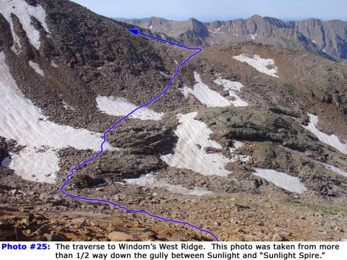
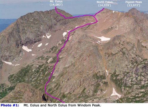
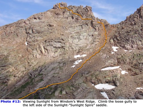
ROUTE: Mt. Eolus is the highest peak of the three, at 14,083 feet. It's most distinguishing feature is the Catwalk, a ridge that narrows to 3 feet wide with 100 foot vertical drops on both sides. However, the hardest climbing occurs later, as you ascend several hundred feet at a 50 degree angle on broken class 3 ledges. For East Couloir approach of Mt. Eolus, head up along the north side of the Needle Creek drainage and around a headwall. From above the headwall climb northwest for 1,800' into the large basin below the East Face of Mt. Eolus. At 13,500' the East Couloir will come into view climber's left. Follow easy trail, then up increasingly steep rock which becomes class 3 to the ridge between Eolus on the left and North Eolus on the right. Turning left, you then cross the Catwalk. The hardest climbing is after the Catwalk. You just go straight up the side on broken ledges about 2 feet wide and 3-5 feet high, climbing from one to the next wherever it looks easist. The climbing is class 3, but exposed. Sunlight Peak is said to be Colorado's hardest fourteener, if difficulty is rated by the hardest single move. All of the hard, class 4 climbing occurs in the last 10 feet. The scariest move for many is a 3 foot step up across an exposed gap dropping hundreds of feet. From your camp in Chicago Basin, hike northeast toward the end of the basin on the great trail. Near 11,200', turn left toward Twin Lakes at a signed junction. This trail is used to reach Windom, Sunlight, and Eolus. Continue up through the trees and past some rock slabs -. Near 11,400', leave the trees where you have a great view of the two streams that flow down from the Twin Lakes area. Follow the trail north up the slope and cross the first stream at 11,700'. Immediately after the crossing, climb steep terrain for 300' before the trail angles right and the slope eases. Continue northeast to the second stream crossing, before 12,300'. Turn left and climb 200' to reach the top of the slope, near the south end of Twin Lakes (~12,500'). Your next goal is to hike around the first lake and continue east. If there is a lot of snow in the area, the easiest way to do this may be to hike around the left (west) side of the first lake and turn right to cross east between the two lakes. When there isn't too much snow, follow the trail around the lake and up through the rocks. At 12,600', reach the base of a headwall that separates you from the upper basin. Water is usually running down the center. Follow cairns and trail segments up the right side and reach the upper basin near 13,000' where there's a great view of the route to 13,800'. In early summer, there may be a lot of snow in the area.Continue east for a bit, then angle left and hike northeast toward talus and boilerplate rock below a gully separating Sunlight and "Sunlight Spire". Continuing northeast up through talus, look for cairns that lead into the gully. After reaching the dirt-filled gully, climb 400' east up to the left side of the gully. Near the saddle, turn left and climb into a notch on the left. The remaining route includes Class 3 climbing and a bit of route finding. Climb from the notch, traverse under some initial cliffs and then scramble toward the ridge to a location where you may find a hole in the ridge. You can pass through this hole to reach the summit, but it involves more difficult ledge climbing on the east side of the ridge. Turn left and walk over to another section of steep rock. Look for cairns and/or the easiest way up and climb these rocks. Before reaching the top, swing left to enter a small chimney with a hole at the top. The hole has a large rock across the top. Climb up through the hole to reach ledges on the east side of the ridge. Turn left and walk up toward the final summit pitch.The final summit pitch is very exposed but the rock is "grippy" when dry. The easiest way up is shown in Pick your line and gain the summit. If you're comfortable with it and the rock is dry, the easiest way off the summit may be to jump from rock to rock. To climb Windom after Sunlight, angle left after descending the gully, traverse across rock and above ledges near 13,200' and then hike southwest up to Windom's West Ridge. Windom Peak is the easiest of the three mountains, just a class 2+ boulder hop to the summit. Climb up to the saddle between Windom Peak and Peak 18 (13,472). From the saddle, climb east up Windom’s west ridge following the path of least resistance. The going gets a little more difficult after you pass a sort of false summit along the ridge. Near the summit, the class 2+ going gets still a little more complicated. At last you will reach the large, cube-like boulders which compose the summit. CAMPING is allowed the entire length of the Needle Creek trail (with many good potential spots along the way), originally a mining trail, which stretches 6 miles from near the train drop-off up to upper Chicago Basin. Be aware of the 100 ft. distance required between your tent and any water source, however. Most parties prefer to set up camp in Chicago Basin itself, as it is the most scenic here, and the approach for the actual climb is the shortest from this point. Also, camping is not permitted at Twin Lakes or within the closure area. Check for the few sites right out of the closure area that are also at least 100' from water. Rangers patrol the area frequently, and may cite you if you disobey. |
|
 July 20-22, 2018 -
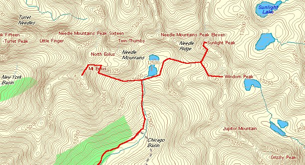
 Eolus, just before crossing the Catwalk
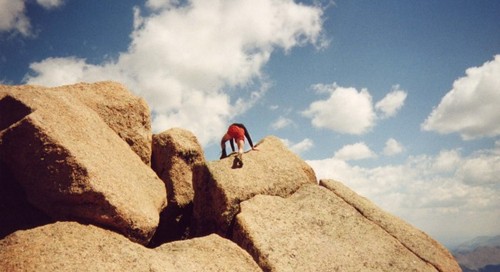 Climbing the summit block on Sunlight Peak