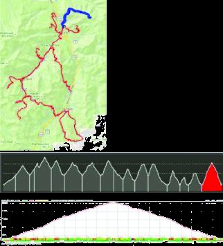
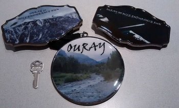
Ouray 100 Mile Endurance Run - Ouray, Colorado
Elevation Gain: 41,862' .........13,365' high.........7640' low...........10,239' average
twilight 0505 - 2128 ............... weather .............. 1 2 3 4 reports
July 27, 2018 - 0800 Start, 52 hrs; PPU 1600-1900 on July 26 w/pre-race mtg at 1800; dropdn by 7/26

|
# |
M |
Section |
TM |
Elev+ |
Elev- |
DB |
Pacer |
CutOff |
Target (Night) |
|
|
0
|
START Fellin Park-> |
0
|
Fri
0800
|
|||||||
|
1 |
5.5 |
-> Lower Camp Bird AS |
5.5 |
2379 |
303 |
|
Fri 0945 |
|||
|
2 |
6.0 |
-> Silver Basin -> Lower Camp Bird AS |
11.5 |
2080 |
2080 |
Fri 1130 |
||||
|
3 |
2.1 |
-> Richmond AS |
13.5 |
1332 |
130 |
Fri 1215 |
||||
|
4 |
7.8 |
-> Chicago Tunnel -> Fort Peabody -> Richmond AS |
21.3 |
3359 |
3359 |
Fri 1515 |
||||
|
5 |
6.0 |
-> Richmond Pass -> Ironton AS |
27.3 |
1763 |
3024 |
Y |
Fri 1930 |
Fri 1715 |
||
|
6 |
8.1 |
-> Corkscrew Gulch -> Gray Copper -> Ironton AS LIGHT |
35.4 |
2782 |
2782 |
Y |
P30
|
Fri 2320 |
Fri 1915 |
|
|
7 |
8.2 |
-> Gray Copper -> Corkscrew Gulch -> Ironton AS |
43.6 |
2782 |
2782 |
Y |
P30
|
Sat 0310 |
Fri 2230 |
|
|
8 |
6.0 |
-> Richmond Pass -> Richmond AS (water only) |
49.5 |
3003 |
1747 |
P30
|
Sat 0045 |
|||
|
9 |
4.2 |
-> Weehawken AS |
53.7 |
122 |
2328 |
Y |
P30
|
Sat 0825 |
Sat 0200 |
|
|
10 |
5.1 |
-> Alpine Mine Overlook -> Weehawken AS |
58.8 |
2361 |
2361 |
Y |
P30
|
Sat 1115 |
Sat 0415 |
|
|
11 |
7.1 |
-> Hayden Pass -> Crystal Lake AS |
65.9 |
3611 |
2749 |
Y |
P30
|
Sat 1500 |
Sat 0715 |
|
|
12 |
8.6 |
-> Hayden Pass -> Fellin Park AS |
74.5 |
2628 |
4553 |
Y |
P26
|
Sat 1940 |
Sat 1045 |
|
|
13 |
6.3 |
-> Twin Peaks -> Silvershield AS |
80.8 |
3450 |
3503 |
Y |
P26
|
Sat 2320 |
Sat 1315 |
|
|
14 |
4.0 |
-> Fellin Park AS |
84.8 |
1968 |
1919 |
Y |
P26
|
Sun 0200 |
Sat 1515 |
|
|
15 |
6.7 |
-> Chief Ouray Mine -> Fellin Park AS LIGHT |
91.5 |
3399 |
3399 |
Y |
P26
|
Sun 0600 |
Sat 1915 |
|
|
16 |
10.6 |
-> Bridge of Heaven -> Finish Fellin Park |
102.1 |
4844 |
4844 |
Y |
P26
|
Sun
1200
|
Sat 2200 |
|
| FINISH in 44 hours ..................AS with DB |
Sun
0400
|
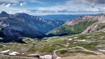
Section 1: Fellin Park -> Lower Camp Bird Aid Station (5.5 miles) 5.5
Overview:
Runners leave Ouray via unpaved surface roads and a brief section
of the Ouray Perimeter Trail before travelling up Camp Bird
Road, a famous Jeeping route. This section of the race has some
overlap with Hardrock 100 and Imogene Pass Run.
Technical Difficulty: Very low with the exception of some steps
before the tunnel that feeds the Box Canyon Footbridge.
Description: Runners begin their journey on the dirt road behind
the gazebo in Fellin Park near the Ouray Hot Springs. Almost
immediately, runners turn left and cross the Uncompahgre River
via a small footbridge. Surface roads (Oak St, Queen St, S Pinecrest
Dr) lead runners to the Perimeter Trail. After a brief section
of easy single track, a very steep section of manmade steps
takes runners up the side of a rock formation and through a
tunnel. Once through the tunnel, which is not quite tall enough
to stand in, runners are treated to some stellar views as they
cross Box Canyon footbridge suspended high above Canyon Creek.
Another brief section of easy single track drops runners onto
the unpaved Camp Bird Road where they climb for 4.3 miles to
the first aid station. The Lower Camp Bird AS is located at
a fork in the road. The inactive Camp Bird Mine (https://en.wikipedia.org/wiki/Camp_Bird_Mine)
is visible to your left.
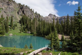
Section 2: Lower Camp Bird AS -> Silver Basin -> Lower Camp Bird AS (6.0M) 11.5
Overview:
Runners tag the upper alpine lake in Silver Basin and return
to the Lower Camp Bird AS.
Technical Difficulty: Low to moderate
Description: Runners leave the Lower Camp Bird AS by taking
a right at the fork and continuing along a popular Jeep route.
The unpaved road climbs and passes under rock overhangs but
remains relatively groomed until runners take a left (off the
Hardrock route) onto the Jeep road that feeds Silver Basin.
At this left, runners take the wooden bridge across Sneffels
Creek and continue onto a more technical Jeep road that winds
its way upward into Silver Basin. Depending on snowmelt, this
road often includes a couple small water crossings, so participants
should expect to get their feet wet. Runners pass the first
of two alpine lakes while still under the tree line. The lakes
have a surreal turquoise hue, the result of rock flour (https://en.wikipedia.org/wiki/Rock_flour)
suspended in the water. Runners continue upward along rocky
double track. The trees give way to panoramas of the mountains
surrounding the basin as well as the more open valley they just
travelled through. Finally, runners top out on some dirt double
track through a field of wildflowers. The road dead ends at
the second alpine lake where runners will find a hole punch.
Runners hold punch their bib to prove they made the trip. Runners
then retrace their steps back down to the Lower Camp Bird AS.
Section 3: Lower Camp Bird AS
-> Richmond AS (2.1 miles) 13.5
Overview:
Runners pass the Camp Bird Mine and climb alongside Imogene
Creek. This section is on the Imogene Pass Run and follows the
most popular Jeep route in Ouray County.
Technical Difficulty: Moderate - rocky uneven double track,
but with mostly firm footing
Description: This time runners take the left at the fork by
the Lower Camp Bird AS putting runners back onto the famous
Imogene Pass Run route for a bit (that race ultimately continues
to Telluride). Runners dip down briefly and skirt the edge of
the Camp Bird Property, passing some old mining equipment and
boarded up buildings. The road then begins climbing and turns
into rocky double track (a true Jeep road, if you will). Runners
can expect to get their feet wet when they cross Imogene Creek.
On rare occasions there is a board a few feet to the right that
allows a dry crossing, but don’t count on it. Dependent
on snowmelt, this crossing is typically 10-12” deep, give
or take (vehicles use it), and has a pretty low flow rate. But
like anywhere in the steep, high country, this could change
depending on weather. Always use caution and be especially alert
if a bad storm comes up in the basin above you. Think of these
basins as funnels with the drainage or creek being the bottom.
Once through Imogene Creek, the Jeep road continues until it
crosses Imogene Creek again, but this time via a wooden bridge.
The Richmond AS is located at that bridge.
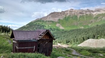
Section 4: Richmond AS > Chicago
Tunnel > Fort Peabody > Richmond AS (7.8 M) 21.3
Overview:
Runners continue upward along the popular Imogene Pass Jeeping
route, detouring through old mining ruins to tag the Chicago
Tunnel. Back on Imogene Pass road, runners continue to the high
point of the course at Fort Peabody (13,365 feet / 4,074 meters)
before returning to the Richmond AS via Imogene Pass Road.
Technical Difficulty: Moderate - rocky uneven double track,
but with mostly firm footing, and a short climb along a field
of talus to reach Fort Peabody
Description: Runners leave the Richmond AS continuing to climb
along the Imogene Pass Road. Runners reach an area known as
Upper Camp Bird, a continuation of the gold mining operations
they passed earlier. The route detours off of Imogene Pass Road
and through Upper Camp Bird. Runners pass through drainages
that often have enough water to get their feet wet again. They
pass old mining ruins as they climb on the increasingly neglected
road that feeds the Chicago Tunnel. The road eventually deteriorates
and narrows to the point it would be impassable in a vehicle.
Of the road areas, this is one of the more technical. Yet, it
is still in the range of moderate compared to the later sections.
Runners top out at the Chicago Tunnel, a simple hole in the
side of the mountain that was once the entrance to a mining
tunnel. Tailings (the term for the broken waste rock from a
mining operation) are visible immediately below the runner.
Large piles of tailings are also visible strewn throughout Upper
Camp Bird, now below the runner. Runners again hole punch their
bib and retrace their steps until they arrive back on Imogene
Pass Road. They continue upward where sparse patches of trees
give way to open fields of wildflowers. Getting farther and
farther above treeline, racers are likely to see countless marmots,
a medium-size ground squirrel. At just over 13,000 feet, almost
to Imogene Pass, runners leave the road and climb a short field
of talus to arrive at the high point of the course, Fort Peabody,
a small shack perched at 13,365 feet. (Hole punch!) On a clear
day, runners have unrivalled views in every direction with mountains
as far as the eye can see. Far below they can see the ground
they just covered with green grass and grey rocks. In the direction
of Imogene Pass, they get a peek at the terrain that the Imogene
Pass Run follows into Telluride. They can also see the distinct
Red Mountains in the distance and even view the zig-zagged Corkscrew
Gulch they will cover during sections six and seven. Finally,
runners retrace their steps along Imogene Pass Road (excluding
Chicago Tunnel this time) and arrive back at the Richmond AS.
Section 5: Richmond AS ->
Richmond Pass -> Ironton AS (6.0 miles) 27.3
Overview:
Jeep roads, a short cross country section, and single track
take runners over Richmond Pass and down to Hwy 550. A brief
(and rare) flat section through Ironton Park connects runners
to the Ironton AS.
Technical Difficulty: Moderate - uneven rocks on the old Jeep
road, some of which are loose, cross country section has larger
rocks and can have lingering snowpack, the descent to Hwy 550
is steep but footing is decent
Description: From the Richmond AS, runners follow a lower-traffic
Jeep road that starts off mild, but gets increasingly technical
as it climbs above treeline. Looser rocks make this one of the
more challenging road sections. Near Richmond Pass, runners
leave the road and follow markings through a field of grass
and large rocks. Once over Richmond Pass, runners follow single
track with magnificent views of the Red Mountains before quickly
losing elevation and dropping back into the trees and down to
Hwy 550 (a.k.a. the notorious Million Dollar Highway https://en.wikipedia.org/wiki/U.S._Route_550).
A few hundred yard of along the dirt shoulder of the highway
connects runners to a dirt road through Ironton Park which leads
to the Ironton AS. Runners will enjoy this small section as
they get a moment of reprieve from the steep terrain.
Note:
Flowers and weeds in the high country can easily grow waist
deep in the summer. Keep an eye out for poison nettle and other
plants that might cause discomfort.
Section 6: Ironton AS -> Corkscrew
Gulch -> Gray Copper -> Ironton AS (8.1 M) 35.4
Overview:
This counterclockwise loop around Red Mountain No. 1 includes
a section of the popular Corkscrew Gulch Jeeping route as well
as the Gray Copper hiking trail.
Technical Difficulty: Low to moderate
Description: Runners follow a Jeep road out of the Ironton AS.
A brief flat section takes runners to a fork. Runners go right
and follow Corkscrew Gulch. As the road winds its way up the
side of Red Mountain No. 1, racers are treated to amazing views
of Red No. 2 and Red No. 3, as well as the mountain range they
crossed to reach Ironton. The views continue to change as runners
loop around Red No. 1 with significant sections above treeline.
A lower-traffic Jeep road cuts off of the main road and passes
by small lakes right at the edge of the treeline. Shortly before
the double track ends at the Vernon Mine, runners catch the
upper trailhead of the Gray Copper Trail. The trail parallels
Gray Copper Creek, crossing it at times, so expect to get your
feet wet. From the lower trailhead, dirt roads bring runners
back to the Ironton AS.
Section 7: Ironton AS -> Gray
Copper -> Corkscrew Gulch -> Ironton AS (8.1M) 43.6
Overview/Description: A clockwise loop around Red Mountain No.
1. This is just section 6 reversed.
Section 8: Ironton AS -> Richmond
Pass -> Richmond AS (water only) (6.0 miles) 49.5
Overview/Description:
This is the reversal of section 5. The only difference is the
Richmond AS will be water only on the return.
(The purpose of the Richmond AS being a full aid station earlier
in the race is so that runners can “top off” after
the Chicago Tunnel and Fort Peabody climbs before heading over
Richmond Pass the 1st time.)
Section 9: Richmond AS (water
only) -> Lower Camp Bird (no AS) -> Weehawken AS (4.2
miles) 53.7
Overview/Description:
Runners are basically retracing their steps. From the water-only
Richmond AS, runners descend Imogene Pass Road to Lower Camp
Bird. Note that on this return trip, there will be no Lower
Camp Bird AS because a new station is open a couple miles farther
down Camp Bird Road at the Weehawken AS (along Camp Bird Road
at the Weehawken Trailhead).
Side Note: It might be helpful to think of sections 8 and 9
as a single section since only water is available midway. While
barely over ten miles when combined, and far from the toughest
terrain on the course, section 8/9 is very tough psychologically,
for several reasons. It’s probably nighttime. The miles
(and many thousands of feet of vertical) are starting to add
up. The runners who haven’t dropped are very spread out.
It’s the last section before pacers can join. Etc. Runners
whose races haven’t been cut short by altitude or fatigue
will get their first big mental test here.
Section 10: Weehawken -> Alpine
Mine Overlook [TAG] -> Weehawken AS (5.1M) 58.8
Overview:
Runners complete a single track out-and-back that takes them
to a scenic overlook at the top of a dramatic cliff where the
Town of Ouray is visible thousands of feet below.
Technical Difficulty: Moderate - some shorts sections of exposure
Description: From the Weehawken AS on Camp Bird Road, the Weehawken
trail begins in the trees and starts climbing immediately. Trees
are peppered around the narrow single track. Runners reach a
fork in the trail and turn right onto Alpine Mine Trail. The
trail climbs and passes the first overlook with some amazing
views of nearby mountains. The trail beyond the first overlook
has some exposure and runners should use extra caution. However,
the trails are in good shape (i.e. not many loose rocks) so
runners should just be careful of footing. Runners top out at
the Alpine Mine Overlook, a cliff standing over 3,000 feet above
Ouray. Some of the 100 mile racers are in for a treat, because
it is a site to see, especially on a clear, quiet night with
the lights of Ouray twinkling below. Finally, runners retrace
their steps back to the Weehawken AS.
Section 11: Weehawken AS ->
Hayden Pass -> Crystal Lake AS (7.1 miles) 65.9
Overview:
Runners descend Camp Bird Road a little more, but then detour
on an old mine road that feeds the Hayden Trailhead. Some challenging
single track takes runners over Hayden Pass before a steep descent
to the Crystal Lake AS.
Technical Difficulty: High - extended sections with loose rocks,
small sections of high exposure
Description: This is one of my favorite sections based on its
uniqueness and difficulty. From the Weehawken AS, runners descend
Camp Bird Road, briefly retracing a small part of section 1
before turning right onto a double track road that feeds the
inactive Cutler Mine. Before reaching the Cutler Mine, runners
reach the Hayden Trailhead and switch over to single track.
Shortly after the trailhead, runners pass through a large area
of fallen, windthrow trees with their roots intact and arranged
vertically. A microburst (high wind event caused by thunderstorms)
likely hit this stand (or group) of trees. Because the ground
was wet, the trees blew over, but the roots stayed largely intact
and were simply pulled out of the ground. Once past the windthrow,
there is an extended section of trail with poor footing. Loose
rocks of various sizes combined with a steep grade make this
one of the more challenging sections, especially on the return
trip when descending—so make note of its location. A buddy
once laughed and called these ball bearing rocks, because sometimes
when stepped on they just roll right out from under you. Past
the ball bearings, the trail continues climbing and passes through
beautiful stands of (upright!) trees. The trail meanders a bit
at the top through sometimes thick vegetation. It’s not
uncommon for the summer plants and flowers to grow waist high
or more. Some are beautiful, and others have sharp points that
will scratch and cut. The descent to Crystal Lake AS is generally
treeless on the upper portion and provides spectacular views,
includes the Red Mountains again. There is a talus slope with
some exposure that deserves extra caution. Just beyond that,
runners are treated to some very unique rock formations. Then
a steep descent through the trees drops runners at the Crystal
Lake AS at Hwy 550.
Section 12: Crystal Lake AS ->
Hayden Pass -> Fellin Park AS (8.6 miles) 74.5
Overview/Description:
This section retraces miles the runners have already seen. From
the Crystal Lake AS, runners climb back over Hayden Pass and
connect with Camp Bird Road. They catch the Ouray Perimeter
Trail, go over the bridge/through the tunnel/down the steps,
and then take the same surface roads back into Fellin Park.
Note: Runners should be very cautious when descending the ball
bearing section. It’s not the most dangerous section as
far as exposure—a slip isn’t going to send you off
a cliff. It’s the fact that you don’t have enough
traction to stop quickly or make any major adjustments. A rolled
ankle/scraped knee/broken wrist/etc. is exactly what you are
asking for if you come flying into this section. I took a good
spill here last summer when the section snuck up on me. I tried
to make a hard turn, lost traction, and slid a good five or
ten feet off the trail/down the hill before I came to a rest.
One of my handhelds bounced another good 20 feet and came to
rest on the next switchback. If you run with a hydration vest,
weight lifting gloves are a good idea on this section and might
save your wrists.
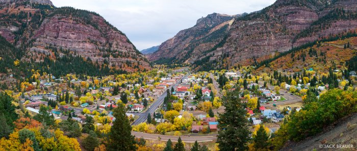
Section 13: Fellin Park AS ->
Twin Peaks -> Silvershield AS (6.3 miles) 80.8
Overview:
From Fellin Park, runners take surface roads to the Old Twin
Peaks Trailhead. An extremely steep climb takes runners to an
intersection. Runners do an out-and-back, tagging the first
peak. Back at the intersection, runners descend via the Silvershield
Trail.
Technical Difficulty: High - extremely steep sections, exposure
just below and on the peak, a short scramble to bag the peak
Description: Runners leave Fellin Park just as they did at the
start of the race (footbridge, Oak St, Queen St). But this time
they stay on Queen St (through the S Pinecrest Dr intersection)
to get to the Old Twin Peaks trailhead. The trail gets increasingly
steep as it proceeds. Per the Ouray Trail Group website, “Around
300 steps were placed using rock, logs and 4x4s, and 607 feet
of cribbing was placed to help hold the trail in this very steep
gorge.” The trail eventually hits a four-way intersection.
Runners continue straight which puts them on the Twin Peaks
trail. The climb continues at a lower grade for a spell before
increasing somewhat. As runners are nearing the top, the trail
leaves the trees and skirts an area of high exposure where runners
need to use extreme caution. The trail isn’t right at the
edge of a cliff, nor is it a bad trail. However, it is on a
grade and can be more dangerous when wet when the risk of slipping
and sliding increases. (Be especially careful when passing this
same section on the descent.) The trail continues, although
with less exposure, until it reaches a rock formation. A small
scramble takes runners to the top of a peak for one hell of
a view. (Hole punch!) Runners then descend the same trail until
they reach the intersection. Runners then go left and descend
via the Silvershield Trail (instead of going straight and continuing
down Old Twin Peaks). Because it is less steep, the terrain
between the intersection and the Silvershield AS is more runnable
than other sections.
Note:
Shortly after you start up the single track on Old Twin Peaks
Trail after leaving town, you’ll come upon a beautiful,
shiney, new footbridge. Don’t go that way! That’s
Oak Creek and adds a couple miles. Your trail instead goes straight/slight
right, up a steep rocky section.
Note: Choosing a shoe with a very aggressive tread pattern is
a must for this race. Due to the elevation gain/loss, this race
is one of the steepest ultramarathons in the world. You are
almost always on a grade. On sections of exposure like the one
mentioned above, having good grip becomes a safety issue, especially
when wet or muddy like we saw in 2015. If your favorite kicks
aren’t doing the trick, another alternative is to install
a bunch of sheet metal screws or IceSpikes in the sole. I still
run in the old Altra Olympus because I’m a frugal bastard
(the newest model has an upgraded sole). After installing six
IceSpikes in each of my old shoes (three in front, three in
back), they grip amazingly well.
Note: Be wary of your GPS mileage on the Old Twin Peaks Trail.
The gorge it follows is narrow and can obscure the sky creating
some pretty funky GPS readings. A storm in 2015 added to the
trouble, but some GPS watches doubled or even tripled the mileage
of this section because they tracked so poorly.
Section 14: Silvershield AS ->
Fellin Park AS (4.0 miles) 84.8
Overview/Description:
Starting at the Silvershield AS, runner retrace their steps
and climb the Silvershield Trail until the intersection with
Twin Peaks Trail. Runners go left at the intersection and descend
via the Old Twin Peaks Trail. Old Twin Peaks will bring runners
back into Ouray. Queen St, Oak St, and the foot bridge will
bring runners back to Fellin Park.
Note: Runners need to be very careful going back down this extremely
steep section. Just plan to walk most of the descent. Take your
time, because losing your footing here could send you bouncing
down the rock and log steps, or falling into the gorge. Grippy
shoes, trekking poles, and fresh headlamp batteries are all
a must. If you have a pacer on this section, make sure they
are prepared as well in terms of gear and goat-like abilities.
Note: If you arrive in Ouray several days early and want to
check out some of the trails on the route, I highly recommend
hiking this steep section of Old Twin Peaks Trail so that you
become familiar with it.
Technical Difficulty: High - descending the steps/trail on Old
Twin Peaks requires extreme caution
Section 15: Fellin Park AS ->
Chief Ouray Mine -> Fellin Park AS (6.7 miles)
91.5
Overview:
Runners follow the Ouray Perimeter Trail past Lower Cascade
Falls and connect with the Chief Ouray Trail. A tough climb
takes runners past Upper Cascade Falls to the Chief Ouray Mine.
Runners return to Fellin Park via the same route.
Technical Difficulty: Moderate to High
Description: Runners leave Fellin Park by heading through the
parking lot toward the (road) entrance of the hot springs pool.
Runners cross the highway and jump on the Ouray Perimeter Trail.
The trail climbs at a low-grade and then descends slightly as
it approaches Lower Cascade Falls. The trail resumes a low-grade
climb and gets moderately technical. The Chief Ouray Trail cuts
off to the left. The grade increases as runners work their way
up switchbacks. Although not as bad as the ball bearings on
Hayden Trail, the Chief Ouray Trail definitely has some challenging
footing in the form of loose rocks and dirt that tend to give
way with much force. As with earlier sections, a shoe with good
grip and trekking poles will serve you well, especially on the
steep dirt. The grade begins to level off as the trail skirts
the bottom of a small cliff. This section has exposure and deserves
some caution, especially for sleepy runners. The trail then
descends slightly to a water crossing at Upper Cascade Falls.
After skirting another cliff, runners arrive at the first building
of the Chief Ouray Mine, the turnaround point. (Hole punch!)
Runners return to Fellin Park by retracing their steps.
Section 16: Fellin Park AS ->
Bridge of Heaven -> Fellin Park AS (10.6 miles) 102.1
Overview:
Briefly using the dirt shoulder of the highway, runners connect
to the Old Horsethief Trail. Old Horsethief climbs steeply until
it hits a ridge. Runners follow the ridge out of the treeline
to the appropriately named Bridge of Heaven before returning
the same way to Fellin Park.
Technical Difficulty: Moderate to High
Description: Runners leave Fellin Park via the parking lot for
a second time. At the vehicle entrance to the hot springs, runners
take a left and briefly run the dirt shoulder of Hwy 550 to
the Old Horsethief Trailhead (the trailhead is on the side of
the road opposite the hot springs). Runners climb switchbacks
in the trees before crossing a section of talus near what is
called The Blowout. The trail continues up more switchbacks
and intersects private dirt roads in the trees before hitting
a ridge. The grade eases somewhat as the trail begins following
the ridge. Single track goes in and out of the trees as it keeps
climbing. Eventually above treeline, the trail continues to
the Bridge of Heaven (hole punch!), a high point along the ridge
with more stunning panoramas. Runners then return via the same
route to Fellin Park. Extra care should again be used when crossing
the talus.


Section
1: Fellin Park -> Lower Camp Bird Aid Station (5.5 miles)
5.5 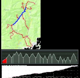
Section
2: Lower Camp Bird AS -> Silver Basin [TAG] -> Lower Camp
Bird AS (6.0M) 11.5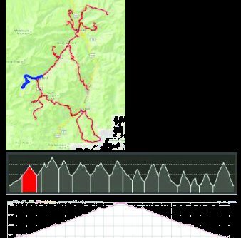
Section
3: Lower Camp Bird AS -> Richmond AS (2.1 miles) 13.5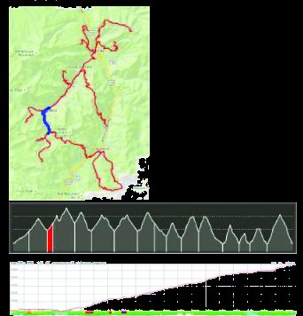
Section
4: Richmond AS > Chicago Tunnel > Fort Peabody > Richmond
AS (7.8 miles)
21.3 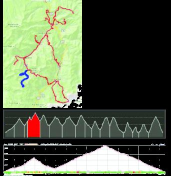
Section
5: Richmond AS -> Richmond Pass -> Ironton AS (6.0 miles)
27.3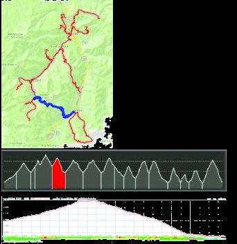
Section
6: Ironton AS -> Corkscrew Gulch -> Gray Copper ->
Ironton AS (8.1 miles) 35.4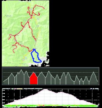
Section
7: Ironton AS -> Gray Copper -> Corkscrew Gulch ->
Ironton AS (8.1 miles) 43.6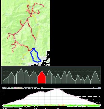
Section
8: Ironton AS -> Richmond Pass -> Richmond AS (water only)
(6.0 miles) 49.5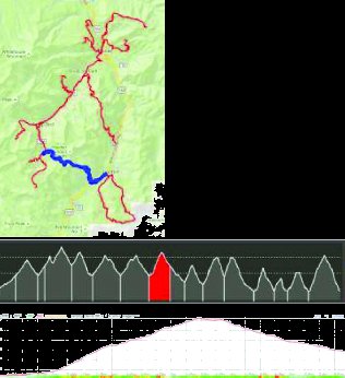
Section
9: Richmond AS (water only) -> Lower Camp Bird (no AS) ->
Weehawken AS (4.2M) 53.7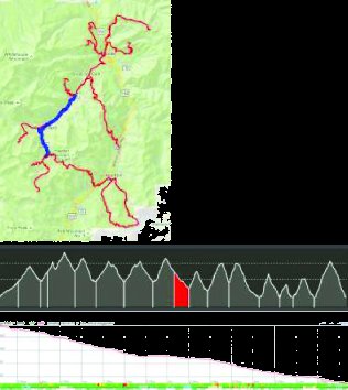
Section
10: Weehawken AS -> Alpine Mine Overlook [TAG] -> Weehawken
AS (5.1M) 58.8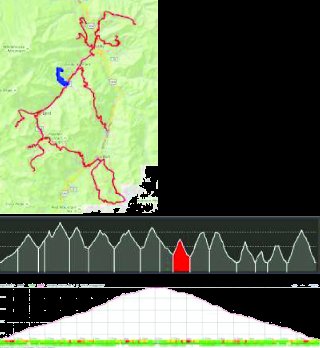
Section
11: Weehawken AS -> Hayden Pass -> Crystal Lake AS (7.1
miles) 65.9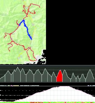
Section
12: Crystal Lake AS -> Hayden Pass -> Fellin Park AS (8.6
miles) 74.5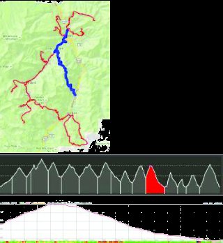
Section
13: Fellin Park AS -> Twin Peaks -> Silvershield AS (6.3
miles) 80.8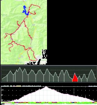
Section
14: Silvershield AS -> Fellin Park AS (4.0 miles) 84.8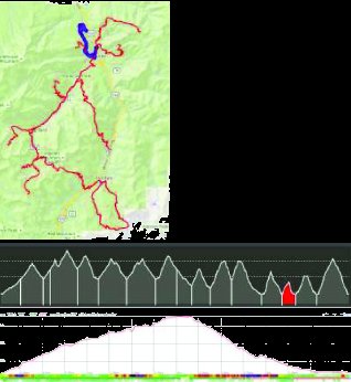
Section
15: Fellin Park AS -> Chief Ouray Mine -> Fellin Park
AS (6.7 miles) 91.5
Section
16: Fellin Park AS -> Bridge of Heaven -> Fellin Park
AS (10.6 miles) 102.1