April 23, 2024 - Mount Shasta is the second highest peak in the Cascade Range, surpassed only by Mount Rainier which is just 249 feet taller. Nonetheless, with a base diameter of more than 17 miles, Mount Shasta has the greater volume. The mountain is one of the southernmost volcanoes in the Cascades, with only Lassen Peak further south. Shastina, Mount Shasta's largest subordinate peak, is the third highest summit in the range. Shasta is also one of the youngest of the Cascade's major volcanoes. This is visible in the mountain's pointed, conical cap. Other major peaks like Mounts Rainier, Adams and Hood are older and have broader, more rounded summits. The last eruption occured in 1786; the sulphur springs near the top of Mount Shasta give warning that the mountain will reawaken in the future. Nearly 7,000 feet of Mount Shasta’s height is above the timberline. Consequently, this is among the most barren wilderness areas in northern California. The lushest forest within the boundary is found on the northeast and southeast slopes of the mountain. Glaciers, tundra and massive screefields dominate the rest of the area, although small meadows punctuate the lower flanks of Mount Shasta. The wilderness area also contains several lava flows, most of which are found on the north side of the mountain. The newest flows are in the northwest, nearest the Bolam trailhead. Older flows can be observed in the North Gate area.
            0M     6880'  Bunny Flats
             1.7M     7880'  Horse Camp Lodge
             2.75M    9200'  50/50 Flat
             3.5 M  10,400'  Lake Helen campground
             4.2M   12,800'  Red Banks - 2200' in less than one mile
             4.5M   13,200'  Misery Hill after raching the Thumb and crossing glacier
             5.0M   13,900'  Base of Summit
             5.2M   14,179'  Summit
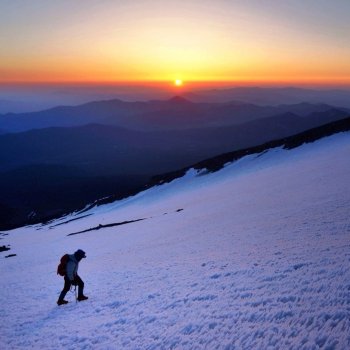
Rising early under the light of the reflection of a full moon on the snowy landscape, I donned crampons and was on the trail at around 0445. It was bright enough to see without a flashlight, but I used one to discern direction among braided snowy tracks going in every direction. There really is no defined trail up Mt. Shasta, especially atop several feet of snow. One has to rely on common sense and experience to keep adjusting to the likeliest set of tracks to follow. There are steeper paths and some that are even dangerous that are better to avoid. For the most part I had little problem in navigating in the dark. The climb was fairly straightforward up to Horse Camp and then Lake Helen at half way - just a slugfest with the ascending relief, one step at a time, keeping breathing within reason, and not sweating. Temps at the start were a mild 38 degrees and there was negligible wind, so it was easy to push too hard and sweat, but I did well at pacing myself and arriving halfway comfortably. Only two people were ahead of me by a mile or so, with absolutely no one coming up behind. The summit was occluded by clouds, so the sunrise was dramatic as the moon set to the west. Once I caught up to the other two at Lake Helen - a ski instructor and EMT nurse from Summit County, Colorado - Jamey and Maddy - I tracked ahead of them up the steep Red Banks section, then took a break once we reached the Thumb before they skied and snowboarded back down, while I continued up over Misery Hill. By the time I got to the top, serious weather was moving in from the west, with giant thunder clouds building and puffy white clouds drifting back over the summit. As I began to descend, visibility dropped to near zero within the cloud, but fortunately it did not snow. I quickly postholed it back down to the Thumb. It was critical to get past the corniced snow at the top of the glacier and descend the same gulch that I climbed to reverse my route successfully. People die up there and I didn't want to be one of them. After glissading most of a mile, much of the day was again a slugfest with exhausting postholing most of the way back down in snow softened by warming afternoon temps. By the time I arrived back at the car at Bunny Flats at 4:30 in the afternoon I was extremely exhausted, an effect that I didn't fully recover from in the following week. It was great to climb another 14er, but I no longer have the moxy that I had even a few years ago. This sort of physical challenge is now approaching an age-enforced limit that I have no experience with and little control of. As I approached 12,000 feet in elevation, my new limits gobsmacked me as I was gasping for air, unlike I have ever experienced. The advantages of youth have, regrettably, further slipped away over the intervening years. I could still breathe fine at rest without discomfort above 14,000 feet in elevation, but the writing is on the wall - I may have to let dreams of more climbing fall by the wayside in my advancing years. Still, it was great to take on this bucket list challenge and once again look down at the world from where the gods abide from such a magical place.
|
 Climbing Mt. Shasta, California